Maps of Afghanistan
Home → Places → Maps
Afghanistan’s position between Central, South and West Asia has shaped its landscapes, trade routes, languages and history.
Location and neighbours
Afghanistan is landlocked. It shares borders with Iran, Pakistan, Turkmenistan, Uzbekistan, Tajikistan and, through the narrow Wakhan Corridor, China. Mountain ranges divide the country into distinct regions and make many journeys follow valleys and passes.

From the original Afghan Desk map archive
Provinces
The country is divided into 34 provinces. Kabul is both the national capital and the name of the surrounding province. The provincial map below is included as a general geographic reference; boundaries and labels should be checked against an up-to-date authoritative map when precision matters.
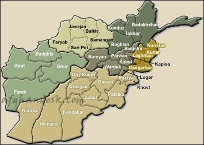
From the original Afghan Desk map archive